Map and directions
Location and how to get there

You will find the facilities constituting Heinrich Heine University (HHU) and the University Hospital (UKD) in the south of Düsseldorf, only around 3.5 km from the centre of town and the main station.
![]() Interactive Campus Explorer (needs Javascript)
Interactive Campus Explorer (needs Javascript)
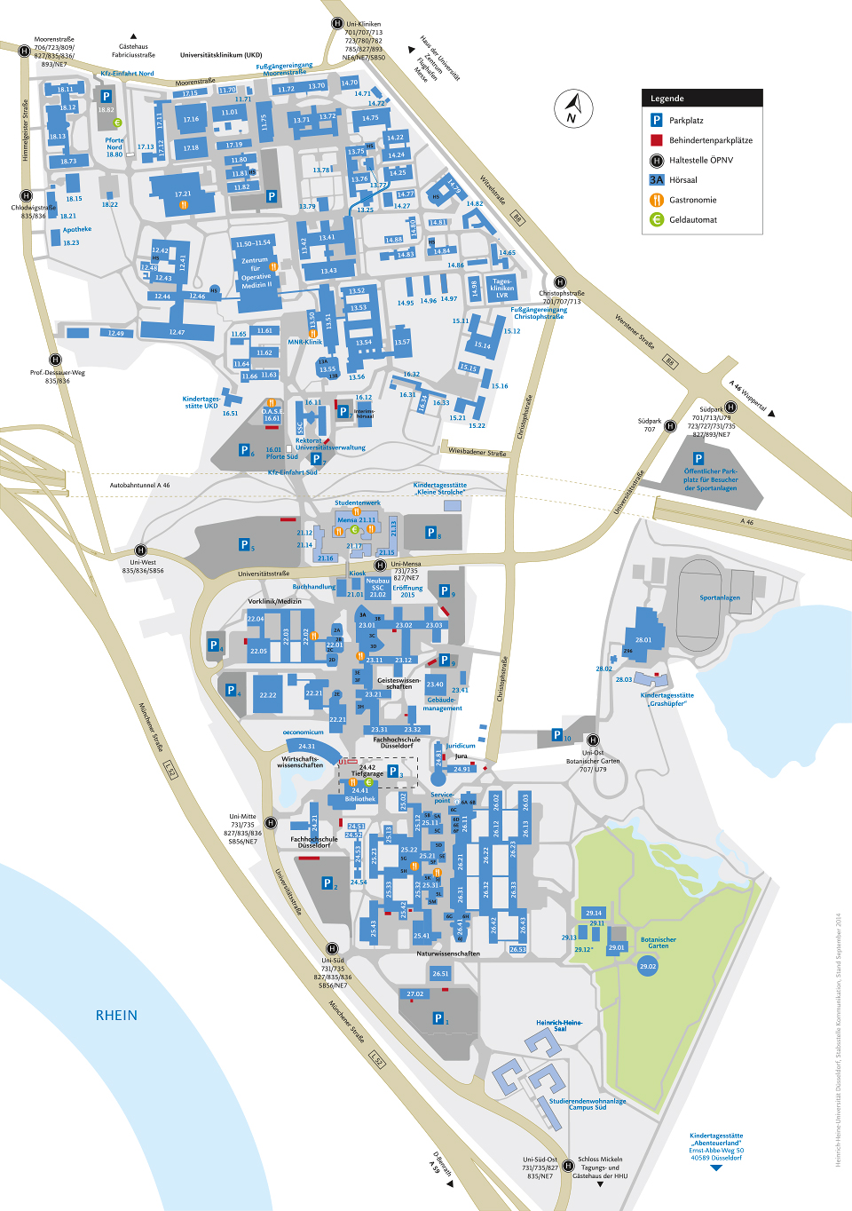
Map HHU campus and UKD print-version (pdf)
Map HHU campus and UKD smartphone-version (jpg)
Surrounding Area (pdf)
Arriving by public transport:
Travel information
The university campus is a small town within a town which is why it has many stops for buses and trams. A special offer for fresher, but also for all other students, is the ![]() Campus Timetable of the Rheinbahn. We suggest using the
Campus Timetable of the Rheinbahn. We suggest using the ![]() Rheinbahn's timetable to find the quickest way to reach your goal:
Rheinbahn's timetable to find the quickest way to reach your goal:
 Faculty of Law
- Faculty of Mathematics and Natural Sciences
- Faculty of Medicine
- Faculty of Arts and Humanities
- Faculty of Business Administration and Economics
- Student Service Centre, President's Office, Central University Administration (building 16.11)
- Canteen (building 21.11)
- Student Services Düsseldorf (building 21.12)
- University Hospital Düsseldorf
- University and State Library Düsseldorf
Arriving by plane
Düsseldorf Rhine-Ruhr airport is one of the biggest in Europe. There is a good connection to the main station by city train (S-Bahn) and from there to the university by tram (line 707 or U79 to the final stop “Uni-Ost / Botanischer Garten”= University east / botanical garden).
Arriving by train
Düsseldorf main station is connected to all international long-distance train routes. Both the U79 and the 707 tram go from there directly to the university. The final stop on both lines is “Uni-Ost / Botanischer Garten” = University east / botanical garden) (marked in the Map HHU campus and UKD). Travel time from the station is around 10 or 20 minutes.
The stops “Uni-Kliniken” (University clinics), “Christophstraße” and “Südpark” (South park) are all within a few minutes’ walk from the university and can be reached using trams 701, 707 and 713.
Arriving by bus
The university is on the route of the following buses: 735, 827, 835 and 836. If you take the 735 or 827 you can get off at “Universität Mensa” (University canteen), “Universität Mitte” (University centre) or “Universität Süd” (University south). If you take the 835 or 836 you can get off at “Universität West” (University west), “Universität Mitte” (University centre) or “Universität Süd” (University south).
Arriving by car
from the East
The university is best reached from Hildener Kreuz (Hilden junction) (A 3 / A 46) via Düsseldorf-Süd junction (Düsseldorf south) (A 46). Leave the A 46 in the tunnel (exit Zentrum / Universität = centre / university). Turn left at the first at the first traffic lights into Universitätsstrasse which runs through the campus.
from the West
The university is best reached from Neuss-Süd junction where the A 46 and A 57 merge. After the Fleher Rhine bridge take the exit Bilk / Zentrum / Hafen / Benrath (Bilk / centre / harbour / Benrath). Stay in the right-hand lane and follow the signs to Benrath / Universität (Benrath / university).
from the city centre
The university is best reached via Corneliusstraße, then Witzelstraße (follow the signs for the A46 and Wuppertal), and then turn right into Universitätsstrasse. Here you will find somewhere to park.
Please note that all parking offenders on university premises will be towed away.
Information for disabled visitors
You can find information about disabled parking and a map in these guidelines from the disability officer.